
Dosya:AOFMap1936.jpg
Bu önizlemenin boyutu: 800 × 582 piksel. Diğer çözünürlükler: 320 × 233 piksel | 640 × 465 piksel | 1.024 × 745 piksel | 1.280 × 931 piksel | 2.200 × 1.600 piksel.
Tam çözünürlük ((2.200 × 1.600 piksel, dosya boyutu: 476 KB, MIME tipi: image/jpeg))
Bu dosya Wikimedia Commons'ta bulunmaktadır. Dosyanın açıklaması aşağıda gösterilmiştir. Commons, serbest/özgür telifli medya dosyalarının bulundurulduğu depodur. Siz de yardım edebilirsiniz. |
Özet
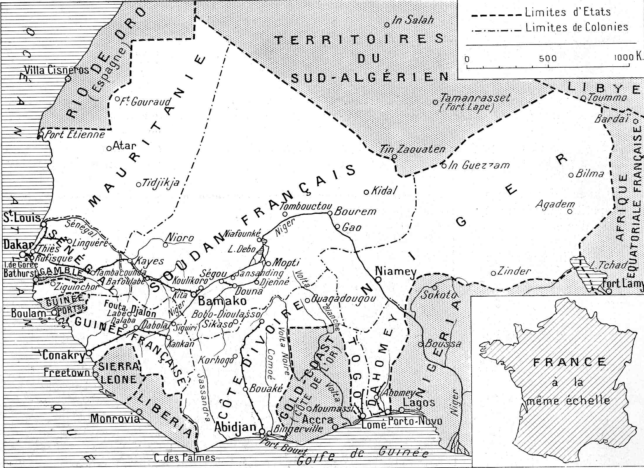
| Açıklama | Carte de l'AOF ("Les sept colonies qui composent l'Afrique occidentale française" in L'oeuvre de la France en Afrique occidentale, numéro spécial de L'Illustration, 29 février 1936, p. 261) |
| Tarih | |
| Kaynak | own document |
| Yazar | anonymous (map) |
| Diğer sürümler | Bu dosyanın türev çalışmaları: AOFmap1936 Soudan français.png |
Lisanslama
This work is in the public domain in France for one of the following reasons:
|
 |
This work is in the public domain in the United States because it meets three requirements:
For background information, see the explanations on Non-U.S. copyrights.
Note: This tag should not be used for sound recordings. |
Dosya geçmişi
Dosyanın herhangi bir zamandaki hâli için ilgili tarih/saat kısmına tıklayın.
| Tarih/Saat | Küçük resim | Boyutlar | Kullanıcı | Yorum | |
|---|---|---|---|---|---|
| güncel | 06.10, 9 Nisan 2008 | | 2.200 × 1.600 (476 KB) | Ji-Elle | {{Information |Description=Carte de l'AOF ("Les sept colonies qui composent l'Afrique occidentale française" in ''L'oeuvre de la France en Afrique occidentale'', numéro spécial de ''L'Illustration'', 29 février 1936) |Source=own document |Date=1936 |A |
Dosya kullanımı
Bu görüntü dosyasına bağlantısı olan sayfalar:
Küresel dosya kullanımı
Aşağıdaki diğer vikiler bu dosyayı kullanmaktadır:
- als.wikipedia.org üzerinde kullanımı
- ar.wikipedia.org üzerinde kullanımı
- azb.wikipedia.org üzerinde kullanımı
- bm.wikipedia.org üzerinde kullanımı
- ca.wikipedia.org üzerinde kullanımı
- da.wikipedia.org üzerinde kullanımı
- de.wikipedia.org üzerinde kullanımı
- en.wikipedia.org üzerinde kullanımı
- es.wikipedia.org üzerinde kullanımı
- eu.wikipedia.org üzerinde kullanımı
- fi.wikipedia.org üzerinde kullanımı
- frr.wikipedia.org üzerinde kullanımı
- fr.wikipedia.org üzerinde kullanımı
- fr.wiktionary.org üzerinde kullanımı
- ha.wikipedia.org üzerinde kullanımı
- he.wikipedia.org üzerinde kullanımı
- hu.wikipedia.org üzerinde kullanımı
- hy.wikipedia.org üzerinde kullanımı
- id.wikipedia.org üzerinde kullanımı
- it.wikipedia.org üzerinde kullanımı
Bu dosyanın daha fazla küresel kullanımını görüntüle.