
Dosya:PIA24027-SaturnMoonEnceladus-IR-MapView-20200929.jpg

Bu dosya Wikimedia Commons'ta bulunmaktadır. Dosyanın açıklaması aşağıda gösterilmiştir. Commons, serbest/özgür telifli medya dosyalarının bulundurulduğu depodur. Siz de yardım edebilirsiniz. |
Özet
| Açıklama |
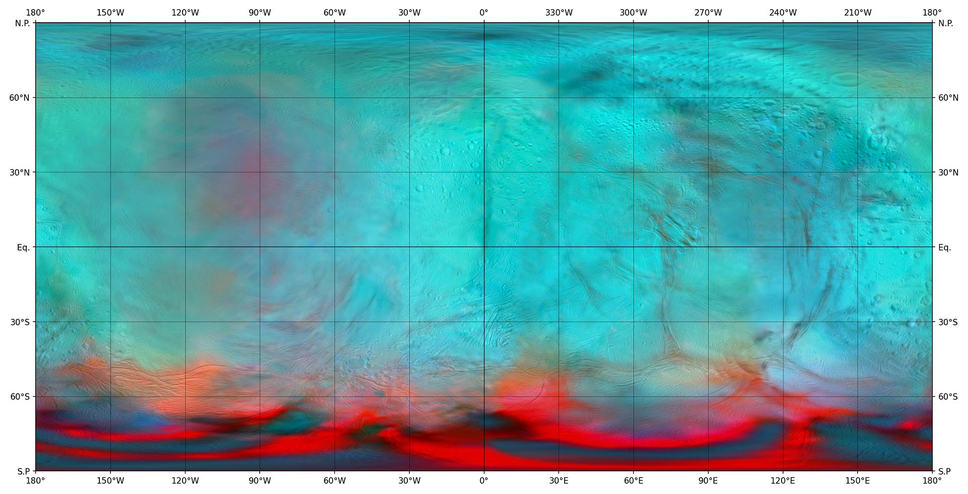
English: PIA24027: Enceladus in the Infrared (Map View)
https://photojournal.jpl.nasa.gov/catalog/PIA24027 This infrared global map of Saturn's icy moon Enceladus was created using images acquired by NASA's Cassini spacecraft. It is a companion to the global views presented in PIA24023. It combines infrared maps obtained by the spacecraft's Visual and Infrared Mapping Spectrometer (VIMS), published by Robidel et al. (2020), and the visible map from the Imaging Science Subsystem (ISS), published by Bland et al. (2018). The colors used in this map represent infrared data collected by the VIMS instrument. The red color channel corresponds to a ratio of Enceladus' brightness observed at 3.1 microns divided by its brightness at 1.65 microns; the green channel corresponds to the brightness at 2.0 microns; and the blue channel corresponds to the brightness at 1.8 microns. These colors highlight the location of fresh crystalline ice, indicated by a red tint. Researchers also superimposed a high-resolution map of the moon's surface taken with the ISS camera (clear filter images), in order to show geologic features. Figure 1 shows a version of the map with a latitude/longitude grid. All seams and spurious artifacts were removed to produce a globally smooth image used in the orthographic views published in PIA24023. This map is an equirectangular projection center at 0° longitude. The mean radius of Enceladus used for the projection of this map is 252.1 km (corresponding to a scale of 200 meters per pixel at the equator). References: - Robidel et al. (2020) - https://doi.org/10.1016/j.icarus.2020.113848 - Bland et al (2018) - https://doi.org/10.1029/2018EA000399 More information about Cassini can be found here: https://solarsystem.nasa.gov/cassini. |
| Tarih | |
| Kaynak | https://photojournal.jpl.nasa.gov/figures/PIA24027_fig1.jpg |
| Yazar | NASA/JPL-Caltech/University of Arizona/LPG/CNRS/University of Nantes/Space Science Institute |
Bu görüntü veya video ABD Ulusal Havacılık ve Uzay Dairesi (NASA) Jet Propulsion Labtarafından Fotoğraf ID: PIA24027 ile kataloğa alınmıştır. Bu etiket, ekli çalışmanın telif hakkı durumunu göstermez. Normal bir telif hakkı etiketi hâlâ gereklidir. Commons:Lisanslama sayfasına bakın. Diğer diller:
|
Lisanslama

|
Bu dosyanın telif hakkı sahibi, NASA/JPL-Caltech, telif hakkına uygun şekilde atıfta bulunmak koşuluyla herkese herhangi bir amaç için bu çalışmayı kullanmak üzere izin vermiştir. |
|
|
| According to JPL's image use policy additional restriction is that no endorsement of any product or service by Caltech, JPL or NASA is claimed or implied.
Caltech's disclaimer: Caltech makes no representations or warranties with respect to ownership of copyrights in the images, and does not represent others who may claim to be authors or owners of copyright of any of the images, and makes no warranties as to the quality of the images. Caltech shall not be responsible for any loss or expenses resulting from the use of the images, and you release and hold Caltech harmless from all liability arising from such use. Usage on the English Wikipedia: On the English Wikipedia you can use the {{JPL Image}} template to display the copyright notice. (See w:Wikipedia:Using JPL images for details) |
Dosya geçmişi
Dosyanın herhangi bir zamandaki hâli için ilgili tarih/saat kısmına tıklayın.
| Tarih/Saat | Küçük resim | Boyutlar | Kullanıcı | Yorum | |
|---|---|---|---|---|---|
| güncel | 11.56, 30 Eylül 2020 | | 1.920 × 980 (806 KB) | Drbogdan | Uploaded a work by NASA/JPL-Caltech/University of Arizona/LPG/CNRS/University of Nantes/Space Science Institute from https://photojournal.jpl.nasa.gov/figures/PIA24027_fig1.jpg with UploadWizard |
Dosya kullanımı
Bu görüntü dosyasına bağlantısı olan sayfalar:
Küresel dosya kullanımı
Aşağıdaki diğer vikiler bu dosyayı kullanmaktadır:
- ro.wikipedia.org üzerinde kullanımı