
Dosya:STS-3 infrared on reentry.jpg
Bu dosya Wikimedia Commons'ta bulunmaktadır. Dosyanın açıklaması aşağıda gösterilmiştir. Commons, serbest/özgür telifli medya dosyalarının bulundurulduğu depodur. Siz de yardım edebilirsiniz. |
Özet
| Açıklama |
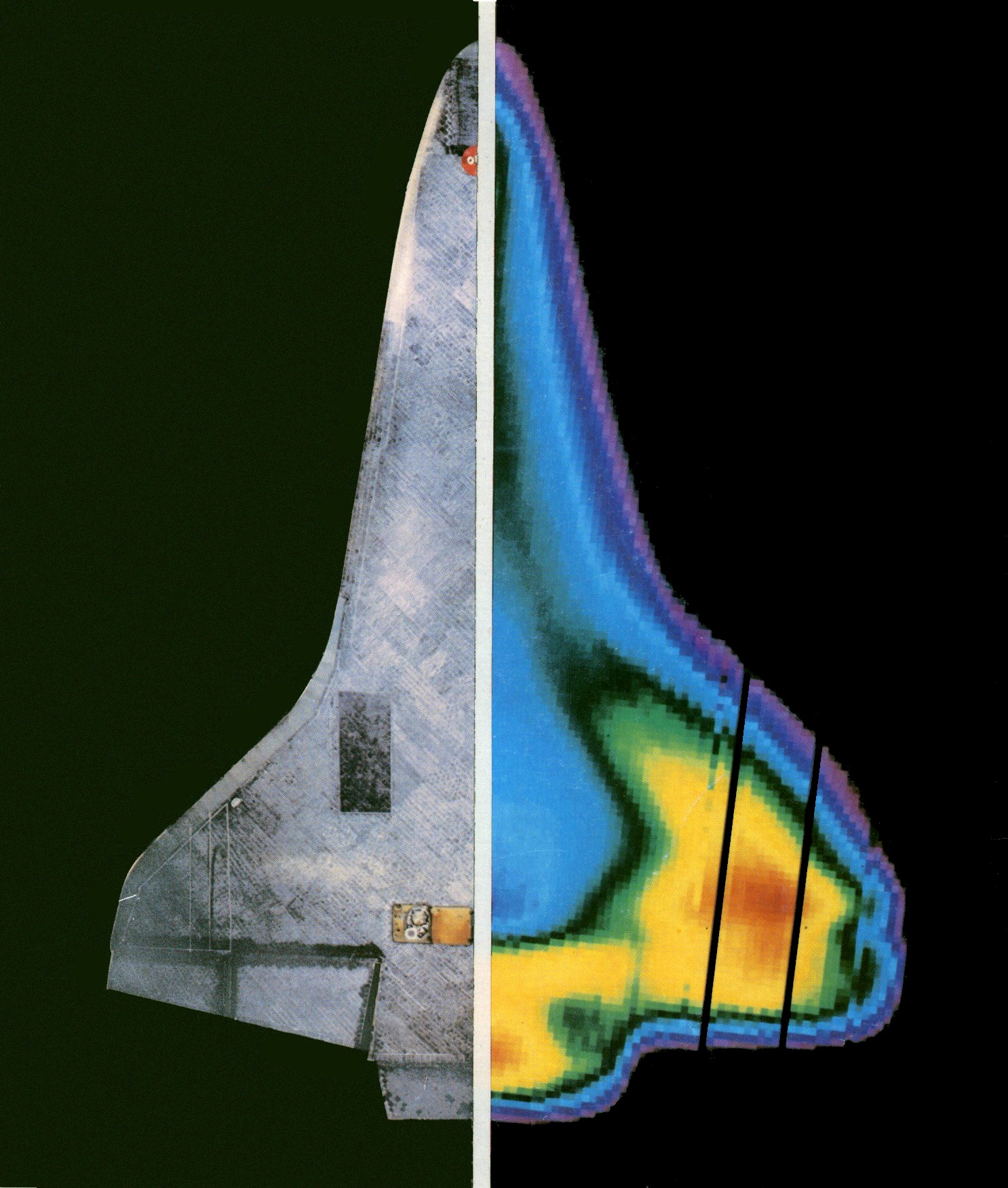
English: Infrared Camera "Takes Shuttle's Temperature"
As the Shuttle Orbiter Columbia returned to Earth, March 30, 1982, an airborne infrared telescope made this image of its heating patterns. The "heat picture" (right half) was taken aboard NASA's Kuiper Airborne Observatory, a Lockheed C-141 Starlifter aircraft specially equipped with a 91.5-cm (36-in.) aperture Cassegrain-type reflector telescope. The Kuiper Observatory aircraft made the image as Columbia raced overhead at a height of 56 kilometers (185,000 feet) at a speed of Mach 15.6. For comparison purposes the heat image of the returning Shuttle Orbiter is shown at the right in the illustration, with a picture of the bottom surface of the spacecraft shown as the other half (left). Nose and main landing gear doors are plainly visible on the left side, as are the leading edge thermal protection surfaces and the elevon hinge area. The dots enclosed by white circles (near the nose and just right of the elevon hinge toward the center line) are the umbilical connectors for mounting the Orbiter on the Boeing 747 ferry aircraft. The vertical black lines toward the outside of the wing/elevon on the heat image side (right) were caused by two inoperative sensor channels. Sensors incorporated in the experiment, called the Infrared Imagery of Shuttle (IRIS), collected readings resulting in this computer-generated image of Columbia's underside. Hottest areas appear red and the least hot areas violet. Thus, these colors in the heat image represent the temperature gradation:
The Shuttle Orbiter was designed to withstand temperatures of 1650 degrees C (3000 degrees F.) on its reinforced carbon/carbon leading edge surfaces and 1315 degrees C (2400 degrees F.) on its most heat-resistant tiles. Highest temperatures on re-entry for the third Shuttle test mission reached 1544 degrees C (2840 degrees F.) on reinforced carbon/carbon surfaces in the nose area. Assignment of temperature values or ranges to each of the colors awaits careful study and adjustment of the IRIS image. Because Columbia and the observatory airplane were not directly above and below each other when the heat image was made, data must be corrected and adjusted with computer assistance. The final image should appear as it would if the line-of-sight axis of the telescope were at right angles to the under surface of Columbia.The re-entering spacecraft showed a 41.5-degree angle of attack and a 59-degree roll angle. Scientists and engineers refer to this procedure as "orthogonalizing" the data. Heat data derived from the adjusted infrared image will be compared with simultaneous readings from seven thermal sensors on the underside of the Orbiter. Kuiper Observatory's heat image was made approximately 150 miles south of Los Angeles, late in the 129th orbit of the third Shuttle test mission. At the time, Columbia was 16.5 minutes into atmosphere re-entry and approaching the coast of Mexico's Southern California Peninsula. Kuiper Airborne Observatory is based and operated by NASA's Ames Research Center, Mountain View, California. The IRIS experiment is funded by NASA's Office of Aeronautics and Space Technology, Washington, D.C. IRIS data are expected to assist in continued development of improved thermal protection materials, an effort for which Ames Center has major responsibility. Classroom Discussion
Final Report Infrared Imagery of Shuttle (IRIS) experment: IRIS/STS-3 engineering report. NASA Ames Research Center, Project Technology Branch (SPT). June 23, 1982. |
| Tarih | 09:18-08:00 |
| Kaynak | NASA handout HqL-117 |
| Yazar | NASA |
| Diğer sürümler |
|

| Kamera pozisyonu | | Bu ve diğer görüntülerin konumlarını şurada belirle: OpenStreetMap |
|---|
| Nesne pozisyonu | | Bu ve diğer görüntülerin konumlarını şurada belirle: OpenStreetMap |
|---|
See also
- Thomas Horvath et al. Shuttle Entry Imaging Using Infrared Thermography 39th AIAA Thermophysics Conference AIAA 2007-4267
25-28 June 2007. Miami, FL.
Lisanslama
| Bu dosya NASA tarafından üretildiği için kamu malıdır. Aksi belirtilmediği sürece "NASA tarafından üretilen malzemenin telif hakkı olmadığı" NASA telif politikasında belirtilmiştir. (Bkz. Template:PD-USGov, NASA copyright policy page veya JPL Image Use Policy.) | ||
 |
Uyarılar:
|
Dosya geçmişi
Dosyanın herhangi bir zamandaki hâli için ilgili tarih/saat kısmına tıklayın.
| Tarih/Saat | Küçük resim | Boyutlar | Kullanıcı | Yorum | |
|---|---|---|---|---|---|
| güncel | 04.21, 18 Mayıs 2013 | | 1.486 × 1.752 (489 KB) | Ke4roh | add some noise in the black sky on the visible image side so it looks more like the original and not so weird |
| 04.17, 18 Mayıs 2013 |  | 1.486 × 1.752 (353 KB) | Ke4roh | Increase saturation (closer to what I see on the paper) Make black areas uniform (to remove scratches) - this loses a bit of noise in the sky on the left side. Touched up one egregious scratch in the purple region on the aft port wing | |
| 00.32, 17 Mayıs 2013 |  | 1.486 × 1.752 (658 KB) | Ke4roh | User created page with UploadWizard |
Dosya kullanımı
Bu görüntü dosyasına bağlantısı olan sayfalar:
Küresel dosya kullanımı
Aşağıdaki diğer vikiler bu dosyayı kullanmaktadır:
- af.wikipedia.org üzerinde kullanımı
- ar.wikipedia.org üzerinde kullanımı
- en.wikipedia.org üzerinde kullanımı
- es.wikipedia.org üzerinde kullanımı
- eu.wikipedia.org üzerinde kullanımı
- fa.wikipedia.org üzerinde kullanımı
- fr.wikipedia.org üzerinde kullanımı
- he.wikipedia.org üzerinde kullanımı
- id.wikipedia.org üzerinde kullanımı
- ja.wikipedia.org üzerinde kullanımı
- kn.wikipedia.org üzerinde kullanımı
- ko.wikipedia.org üzerinde kullanımı
- pt.wikipedia.org üzerinde kullanımı
- ru.wikipedia.org üzerinde kullanımı
- sr.wikipedia.org üzerinde kullanımı
- te.wikipedia.org üzerinde kullanımı
- uk.wikipedia.org üzerinde kullanımı